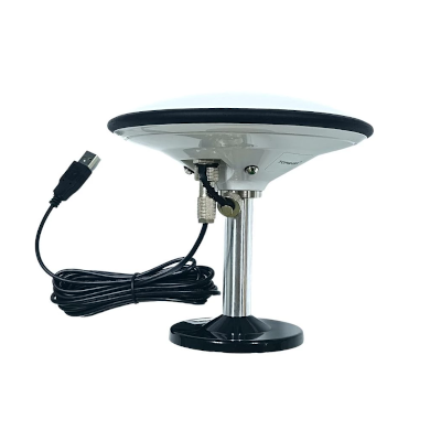
TOP168 RTK Base Station GNSS Receiver (ZED-F9P multi-band RTK, RTCM3.3, Operating temperature -40 °C ~ +85°C )
TOP168 RTK Base Station GNSS Receiver (ZED-F9P multi-band RTK, RTCM3.3, Operating temperature -40 °C ~ +85°C )
Country of Origin: China
Couldn't load pickup availability
Volume Discount Table
| Minimum Qty | Discount |
|---|---|
| 2 + | 5% off |
| 5 + | 6% off |
| 10 + | 7% off |
| 100 + | 9% off |
TOP168 RTK GNSS receiver can reach up to 1.4cm positioning accuracy. It integrated a u-blox ZED-F9P RTK Module with a high-precision multiband “ufo” antenna. The 168mm antenna can effectively reduce the GNSS signal “phase delay” or “missing phase center” issues, which made TOP168 an excellent candidate to be set up as a RTK base station.
TOP168 has 184 channels, receiving data from 4 constellation satellite positioning systems including GPS, GLONASS, Galileo and Beidou. It outputs RTCM and NMEA0183 protocol via USB and Bluetooth.
Setup your own cost-effective NTRIP / CORS solution
Is your NTRIP service subscription plan too expensive to afford? Or if your most available NTRIP Caster mount point is too far away? If the answer is yes, you should set up your own NTRIP / CORS solution.
Below is the end to end RTK base station NTRIP solution. It consists
of
1 x TOP168 RTK GNSS Receiver
1 x RTKLib's STRSVR Ntrip Server software (free)
1 x GeoAstra Internet NTRIP Caster Service (free)
Your cost of the solution is just a TOP168 RTK GNSS receiver ($699), a Windows computer and Internet access.
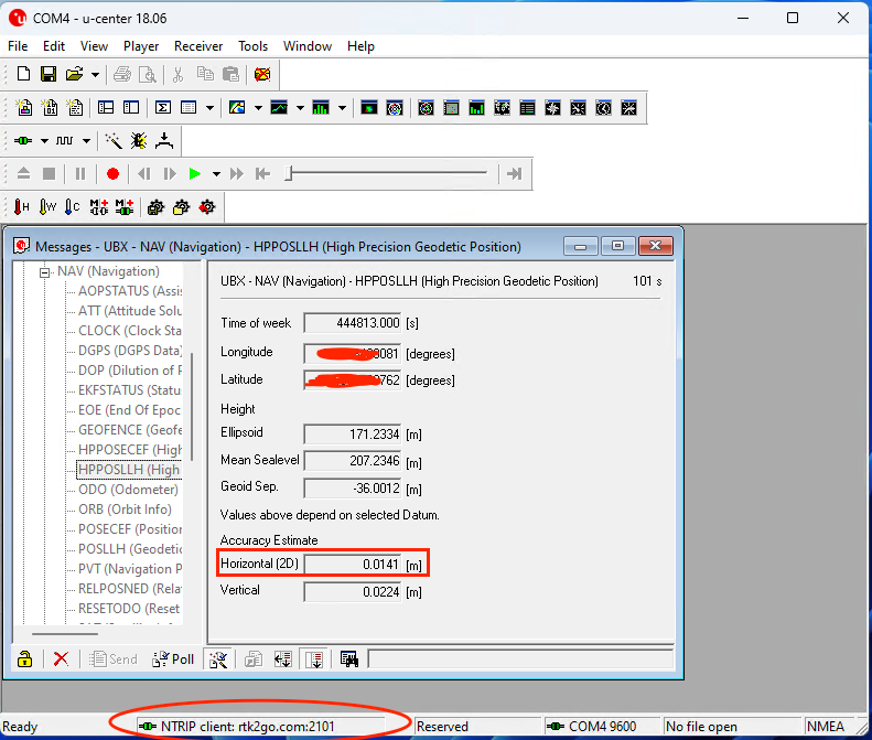
To set it up, please follow the below step by step instructions:We tested the above setup & got a pretty satisfaction result. we achieved 0.0141m horizontal accuracy in our RTK rovers. Please refer to the below screenshot.

RTK base station calibrating options
Option 1: Survey-in
If you deploy a TOP168 in a temporary location, you could use the “Survey-in” calibration
option. TOP608 will acquire the position by itself and run as a RTK base station in a few minutes.
Option 2: Fixed Mode
If you deploy a TOP168 in a permanent location, you could use the “Fixed Mode”
calibration option. You could use TOP168 to collect hours of RAW data and send it for the PPK process. (There are
many free PPK services online these days. For example: CSRS-PPP ) After receiving the PPK process result, you could
manually key in the location data into the TOP168. This option could need more time, but it is more accurate.
RTK reference station ARP(Antenna Reference Point) setup could never be so easy.
Application scenarios:
- High-precision GNSS data collection,
- High-precision navigation positioning,
- High-precision driving,
- Unmanned patrol vehicle,
- Unmanned logistics robot,
- UAV/Drone formation flying base station,
- Precision agriculture
Technical specs:
GNSS Module: U-Blox ZED-F9P
GNSS Frequency: GPS L1/L2,GLONASS G1/G2,BDS B1/B2,GALILEO E1/E5b, SBAS L1/L2,QZSS L1/L2
Constellations: GPS+GLONASS+BDS+GALILEO+SBAS+QZSS
Channels: 184 Search channel
Tracking sensitivity: -167dBm
Capture sensitivity: -160dBm
Accuracy/Precision
Start Time
Output
Work environment
LED status:
Power consumption
Connection: USB,Bluetooth
Dimension
Waterproof level: IPX67
Operating temperature: -40 °C ~ +85°C
Installation threaded hole: 5/8-11UNC
Compatible OS:
Package Content
Product Resources
Official Documents:
Driver Downloads:
-
 Windows 10 / 11 driver installation guide
-
 Linux driver installation guide
-
 Android connection instruction
Tool Downloads:
How to Articles and Blogs:
-
 Build your very own NTRIP RTK Base with just an RTK GNSS Receiver and 5 minutes
-
 How to setup an RTK Base station using a USB / Bluetooth RTK GNSS Receiver?
-
 How to obtain a highly accurate coordinate for your RTK base station?
-
 The Free NTRIP Caster from GPSWebShop
-
 NTRIP RTK products buyers’ guide
-
 NTRIP Casters in the Real World
-
 How accurate does your RTK base need to be?


