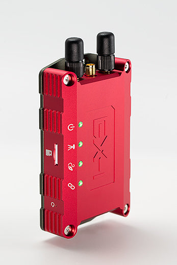


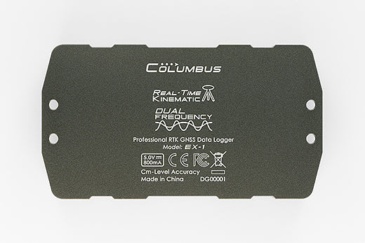


Columbus EX-1 Ultra-High Accuracy RTK GNSS Data Logger (Supports RTK, PPK, and standalone data logging; 30 cm accuracy in standalone mode; up to 1 cm accuracy with RTK or PPK)
Columbus EX-1 Ultra-High Accuracy RTK GNSS Data Logger (Supports RTK, PPK, and standalone data logging; 30 cm accuracy in standalone mode; up to 1 cm accuracy with RTK or PPK)
Country of Origin: China
Couldn't load pickup availability
Volume Discount Table
| Minimum Qty | Discount |
|---|---|
| 2 + | 5% off |
| 5 + | 6% off |
| 10 + | 7% off |
| 100 + | 9% off |
Introducing the Columbus EX-1 Ultra-High Accuracy RTK GNSS Data Logger, a groundbreaking device engineered for unparalleled precision and reliability.
Ultra-High Positioning Accuracy


RTK Mode Accuracy
-
- Horizontal Accuracy: 0.01 m + 1 ppm* (CEP)
- Vertical Accuracy: 0.01 m + 1 ppm* (Median)
- Velocity: 0.05m/s
- Dynamic Heading: 0.3 deg
*Measured using a 1 km baseline, with the ppm limitation applying to a maximum baseline range of 20 km. Velocity and dynamic heading accuracy are based on 50% accuracy at 30 m/s during dynamic operation.
Standalone SBAS Mode Accuracy
-
- Accuracy: 0.3 m* (CEP)
* Based on a 1-hour observation.

Dual-Frequency, All-Constellation
The EX-1 supports all major satellite navigation systems, including GPS, Galileo, BeiDou, GLONASS, and QZSS, while simultaneously receiving L1 and L2 band signals. Dual-frequency GNSS enhances precision by mitigating signal delays caused by atmospheric interference, ensuring accurate measurements even in challenging conditions. With 184 channels, the EX-1 delivers reliable, precise positioning at all times.

Advanced Data Logging
The EX-1 records in multiple formats with update rates of up to 10 Hz, supporting
RTK, PPK, and Standalone Data Logging:
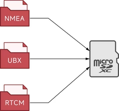
RTK Logging: The EX-1 stores RTK-calculated data in NMEA format, offering comprehensive positioning details such as coordinates, time, speed, heading, altitude, and satellite data. (Supports NMEA 0183 version 4.11)
PPK Logging: For post-processing, the EX-1 records raw data in UBX and RTCM formats. UBX provides complete satellite reception data, while RTCM includes differential corrections and critical information for accurate PPK post-processing. (Supports RTCM 10403.3 version)
Standalone Logging: The EX-1 stores positioning data in NMEA format, offering comprehensive positioning details such as coordinates, time, speed, heading, altitude, and satellite data. (Supports NMEA 0183 version 4.11)
Huge logging Capacity:

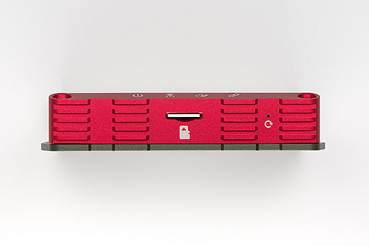
The EX-1 offers extensive storage capabilities with support for microSD cards over 2TB using the exFAT file format, effectively removing storage limitations. Users can choose to utilize card storage as needed.
Exceptional logging Reliability:
The EX-1 consistently delivers exceptional reliability, capable of continuous 24-hour recording at maximum data volume with fewer than one bad data point. This high performance is maintained even during simultaneous recording at 10 Hz in NMEA, RTCM, and UBX (RAW Data) formats, as rigorously validated by Columbus.
Operating Modes:
1. Standalone Mode:

-
- Operates as a standalone GNSS receiver and data logger.
- Independent data logging. No internet, smartphone, or computer is needed. Collected data will be saved into the MicroSD memory card
- Can be used as a standalone GNSS data logger with accuracy of 30 cm.
2. RTK Rover Mode:

-
- Functions as both an RTK GNSS receiver and a data logger.
- Connect the EX-1 to an Android or Windows device to receive CORS or NTRIP services via the internet.
- Achieve up to 1 cm accuracy for real-time positioning and/or track logging.
3. RTK Base Mode:

-
- Serves as an RTK base station, providing real-time correction services to RTK rovers.
- Connect EX-1 to an Android or Windows device to stream RTCM correction data to an NTRIP Caster service, such as GeoAstra, which offers a free, production-grade NTRIP caster service.
- For optimal performance in RTK Base mode, it is recommended to use a disc antenna, such as the BY500.
4. PPK Mode:

-
- Functions as a PPK data logger, requiring two EX-1 devices recording simultaneously.
- Ideal for fieldwork, offline tasks, or environments without internet access, supporting one base station and multiple rover units.
- Configure one EX-1 as the base station and another as the rover. Simply connect a GNSS antenna and insert a storage card.
- No internet, smartphone, or computer is needed during PPK data collection—just the two EX-1 devices.
- After data collection, perform Post-Processed Kinematic (PPK) processing on a computer to achieve track accuracy of up to 1 cm CEP.
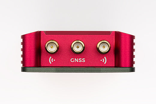
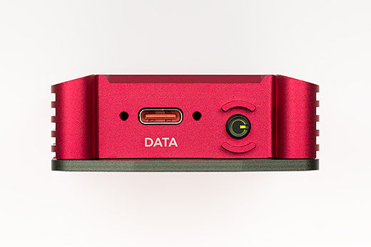
Three Primary Connection Channels:


USB-C - “Data Port” (Upload and Download): Used to download position data from the EX-1 or upload NTRIP data to the EX-1. This port also allows for parameter configuration of the device.

Bluetooth - “NTRIP SPP” (Upload and Download): Used to download position data from the EX-1 or upload NTRIP data to the EX-1.
Bluetooth - “SPP” (Download Only): Used to download position data from the EX-1.
*SPP stands for Serial Port Profile, a widely used Bluetooth transmission protocol in Windows and Android devices.
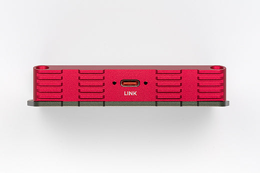
Three Extension Connection Channels:
The EX-1 is built for future expansion, ensuring the ability to connect with new hardware and apps as they become available.

USB-C - “Link Port”: Can be connected to future peripherals, such as an LTE modem (expected availability in 2025).

Bluetooth - “NTRIP BLE”: Enables app-level Bluetooth connections for direct interaction with various iOS and Android apps.
Bluetooth - “BLE”: Offers app-level Bluetooth connectivity, allowing seamless integration with a range of iOS and Android apps.
Aluminum Alloy Housing

EX-1 features a robust and durable housing crafted from CNC-machined, anodized aluminum alloy, providing superior protection for the GNSS engine board. The precision machining not only enhances durability but also adds a high-end, polished finish to the device.
Additionally, the housing includes 4 x M3 mounting holes, allowing for stable and secure installation, minimizing any shifting during measurements, and ensuring consistent accuracy.
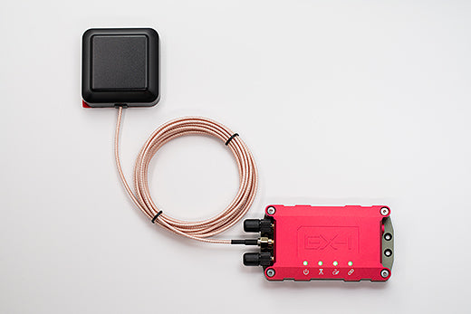
Premium Dual-Feed, Dual-Layer Active Antenna

The EX-1 is equipped with a high-gain, dual-feed, dual-layer ceramic external patch antenna, providing a stable phase center for enhanced positioning accuracy, which is essential for achieving centimeter-level precision. The antenna is also IP67-rated, ensuring it is waterproof and suitable for all-weather conditions.
TimeAlbum™ Pro Software
"TimeAlbum™ Pro" is equipped with the most advanced track editing function and personalized settings with the ability to provide the latest and multiple maps, such as Google and Openstreetmap.
"TimeAlbum™ Pro" can assist in your background work, and can efficiently convert, manage and plan the tracks.
It is compatible with Windows, Linux and Mac OS.

A sample track from the EX-1 loaded into TimeAlum Pro.

High quality doesn’t have to come at a high price

We understand that budget-friendliness is essential for your project’s success. The EX-1 delivers exceptional quality without compromising on cost-effectiveness. With Columbus’s excellent cost control, the EX-1 remains affordable, making the large-scale deployment of extremely high-accuracy GNSS data loggers achievable.
Accuracy Tests
(click here for detailed test information):
The Columbus EX-1 RTK GNSS has undergone rigorous testing to ensure exceptional accuracy across all conditions.
1. RTK Rover Mode - Static Tests:


2. RTK Rover Mode - Dynamic Tests:

EX-1 maintained accuracy even at ultra-low speeds, perfectly tracing a 20 cm radius.
3. RTK Rover Mode - Dynamic Stability Tests:


Further confirmed the EX-1’s reliability, consistently tracking within a 1 cm margin over multiple laps.
4. Standalone Mode - Static Tests:


CEP (50%) accuracy was 0.240130m, surpassing the nominal value of 0.3m.
Tech Specs
Ingress Protection
• External Active GNSS Antenna: IP67
Note: The external GNSS antenna can be used in all-weather environments. The EX-1 body is not waterproof.
Operating Temperature
• -20 °C to 50 °C / -4 °F to 122 °F
GNSS Engine
• u-blox ZED-F9P
• 184 Channels
GNSS Performance
• Upper L-Band (L1): GPS (L1C/A, 1575.42MHz), Galileo (E1B/C, 1575.42MHz), BeiDou (B1I, 1561.098MHz), GLONASS (L1OF, 1602MHz), QZSS (L1C/A, L1S, 1575.42MHz), SBAS (L1C/A)
• Lower L-Band (L2): GPS (L2C/A, 1227.6MHz), Galileo (E5b, 1207.14MHz), BeiDou (B2I, 1207.14MHz), GLONASS (L2OF, 1247MHz), QZSS (L2C, 1227.6MHz)
Positioning Accuracy :
RTK Mode:
• Horizontal Accuracy: 0.01 m + 1 ppm* (Circular Error Probability / CEP)
• Vertical Accuracy: 0.01 m + 1 ppm* (Median)
Standalone SBAS Mode:
• 0.3 m (Circular Error Probability / CEP 50%)
* Measurements are taken using a 1 km baseline. PPM is limited to a maximum baseline range of 20 kilometers. For every additional kilometer between the rover and the fixed station, the error increases by 1 mm. Testing is conducted in areas with a clear sky view.
* Based on a 1-hour static test.
Measurable Range
• Maximum altitude: 80,000 m
• Maximum horizontal speed: 1,800 km/h
• Maximum vertical speed: 72,000 km/h
Positioning Ability
• Acquisition:
• Reacquisition: <2s
• Hot start: <2s
• Cold start: <29s
• RTK convergence time: <5s
• Sensitivity:
• Tracking & Navigation: -167 dBm
• Reacquisition: -160 dBm
• Hot Starts: -157 dBm
• Cold Starts: -148 dBm
*Testing in ideal open environments.
Update Rate
• 1, 5, 10 Hz
Recordable Data
Protocol: NMEA 0183
• Messages (Default): GNRMC, GNGGA, GNGSA, GNGSV
• Geodesics: WGS84
• *Version 4.11
Protocol: UBX
• Messages (Default): UBX-RXM-SFRBX (Code Phase [ms]), UBX-RXM-MEASX (Doppler [m/s, Hz]), UBX-RXM-RAWX (Pseudoranges [m], Carrier phase [cycles])
Protocol: RTCM
• Messages (Default): TYPE1005, TYPE1074, TYPE1084, TYPE1094, TYPE1124, TYPE1230
• *Version RTCM 10403.3
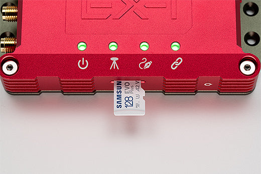
Storage Card
• MicroSD, MicroSDHC, MicroSDXC
• File System: FAT16, FAT32, exFAT
• Capacity Supported: >2TB
Bluetooth
Channel 1: EX-1 NTRIP
• Mode: SPP 2.1, BLE 5.1
• Range: >10 m (33 feet)
Channel 2: EX-1
• Mode: SPP 2.1, BLE 5.1
• Range: >10 m (33 feet)
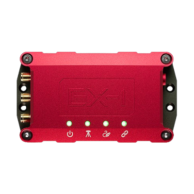
Connectors
• Data Port: USB Type-C
• Expansion Port: USB Type-C
• GNSS Antenna Connector: SMA (Female)
• Bluetooth Connectors: SMA (Female)
Power and Battery
• Built-in 2100mAh rechargeable lithium-polymer battery
• Continuous recording (RTK mode): 10 hours*
• Charging time: Approx 4.0 hours
• Power supplies: DC 5V 800mA
*Continuous logging at 1Hz and 20°C environmental temperature.
Antenna
GNSS Antenna:
• Type: Active antenna
• Polarization: RHCP
• Impedance: 50 Ω
• VSWR: ≤2.0
• Patch Gain: ≥2 dBi
• LNA Gain: 28±2 dB
• Noise figure: ≤1.5 dB
• Connectors: SMA (Male)
• Cable: RG316, 300 cm
• Operating Voltage: 3.3 V
• Current: 40 mA
• Mounting Method: Magnetic with adhesive
Bluetooth Antenna:
• Type: Passive antenna
• Frequency Range: 2.4~2.5 GHz
• Polarization: Vertical
• Impedance: 50 Ω
• VSWR: ≤1.5
• Connectors: SMA (Male)
System Requirements
• Windows 7 or greater
• Mac OS X v10.10 or greater
• Linux 2.6.12 or greater
• iOS 15 or greater
• Android 10 or greater
• iPad OS 15 or greater
Certificates:
• FCC
• CE
• RoHS
Size and Weight


Part Description

Packing List
- EX-1 Professional RTK GNSS Data Logger
- GNSS Antenna
- Bluetooth Transmit Antenna x2
- USB Cable
- Warranty Card
- Helica Antenna Kit (Optional)
Product Resources
Official Documents:
YouTube Videos:
Driver Downloads:
-
 Windows 10 / 11 driver installation guide
-
GNSS Sensor Device driver for Windows 10 /11
-
 Linux driver installation guide
-
 Android connection instruction
Tool Downloads:
How to Articles and Blogs:
RTK Rover:
-
 How to connect a GPS/GNSS Receiver to Google Earth on Windows?
-
How to use a RTK GNSS Receiver for Android: A Step-by-Step Guide
-
Utilizing a USB/Bluetooth RTK GNSS Receiver with a Windows 10/11 Laptop: A Step-by-Step Guide
-
How to Connect a USB/Bluetooth RTK GNSS Receiver to Windows? (Accessing NTRIP Through an Android Phone’s Internet Connection)
-
Utilizing a RTK GNSS Receiver for Linux: A Step-by-Step Guide
-
Utilizing a USB/Bluetooth RTK GNSS Receiver for High Accuracy Data Logging: A Step-by-Step Guide
-
Uninstall “Windows Location Sensor”: A Step-by-Step Guide
-
How to connect a GNSS Receiver to Windows Maps (or Windows Location Service)??
-
NTRIP RTK products buyers’ guide
RTK Base:
-
PPK (Post-Processed Kinematic) by using the Columbus EX-1 GNSS Data Logger
-
How to configure the Columbus EX-1 as an RTK/PPK Base Station in a Production Environment
-
Build your very own NTRIP RTK Base with just an RTK GNSS Receiver and 5 minutes
-
How to obtain a highly accurate coordinate for your RTK base station using PPP method?
-
RTK / PPK Base Station Accuracy: Long-Duration Survey-In vs. PPP (Precise Point Positioning)
-
How to setup an RTK Base station using a USB / Bluetooth RTK GNSS Receiver?
-
The Free NTRIP Caster from GPSWebShop
-
NTRIP RTK products buyers’ guide
-
NTRIP Casters in the Real World
-
How accurate does your RTK base need to be?