
GeoAstra Y55G RTK/PPP GNSS Android Device – 1cm RTK Accuracy / 20cm PPP Accuracy, HAS/B2b Satellite Corrections, Full-Band L1/L2/L5 + E6/B2b, Google Play/GMS Supported
GeoAstra Y55G RTK/PPP GNSS Android Device – 1cm RTK Accuracy / 20cm PPP Accuracy, HAS/B2b Satellite Corrections, Full-Band L1/L2/L5 + E6/B2b, Google Play/GMS Supported
Country of Origin: China
Couldn't load pickup availability
Volume Discount Table
| Minimum Qty | Discount |
|---|---|
| 2 + | 5% off |
| 5 + | 7% off |
| 10 + | 10% off |
The GeoAstra Y55G is a rugged, high-precision Android 14 smart device with built-in professional GNSS positioning technology. It is more than a traditional survey controller or data collector — it is an open Android platform designed for GIS, mapping, robotics, field inspection, asset management, agriculture, construction, and custom Android applications.
With an integrated RTK + PPP high-accuracy GNSS module, the GeoAstra Y55G delivers 1cm RTK accuracy when connected to correction networks and up to 20cm PPP accuracy using satellite-based corrections such as Galileo HAS and BeiDou B2b. This makes it a powerful all-in-one positioning device for users who need reliable high accuracy both with and without RTK network coverage.
Built for real field use, the GeoAstra Y55G combines a rugged handheld design, long battery life, 4G/Wi-Fi/Bluetooth connectivity, full Google Play/GMS support, and compatibility with third-party Android apps. Whether used as a precision GNSS terminal, field mapping device, or custom Android application platform, the Y55G provides high-accuracy positioning in a flexible and easy-to-use form factor.
 PPP Feature Introduction
Achieve 20 cm accuracy anywhere on Earth — no RTK network, no base station, no subscription required.
Galileo E6 HAS PPP — Free Global 20cm Accuracy via Satellite
The GeoAstra Y55G supports Galileo High Accuracy Service (HAS), a next-generation PPP correction service that delivers ~20 cm positioning accuracy globally — without requiring any base station or subscription.
How it works
- Correction data (orbit, clock, bias) is broadcast directly from Galileo satellites via E6 band
- No need for NTRIP / CORS network
- No need for Internet connection
- Works anywhere with clear sky view
→ True satellite-based PPP positioning
Key advantages
- ~20 cm accuracy (global)
- Free service (no subscription required)
- Global coverage (not region-locked)
- No base station needed (unlike RTK)
- Delivered via Galileo E6 signal (HAS)
Why this matters
Most high-accuracy GNSS solutions:
- Require RTK infrastructure
- Or paid correction services
GeoAstra Y55G:
→ Works standalone with decimeter accuracy anywhere in the world
BeiDou B2b PPP — High-Accuracy PPP Optimized for Asia-Pacific
In addition to Galileo HAS, the GeoAstra Y55G also supports BeiDou B2b PPP correction service, providing another ~20 cm accuracy PPP solution, especially optimized for Asia-Pacific regions.
How it works
- Correction data is broadcast via BeiDou B2b signal
- Similar concept to HAS, but powered by the BeiDou system
- Designed for high-performance PPP in regions with strong BDS coverage
Key advantages
- ~20 cm PPP accuracy (decimeter level)
- Satellite-delivered corrections (no ground network required)
- Better performance in Asia-Pacific environments
- Dual PPP sources (HAS + B2b) for redundancy
Dual PPP Engine — Always-On High Accuracy
Unlike most GNSS devices that support only one correction source, the GeoAstra Y55G provides:
- Galileo HAS (global PPP)
- BeiDou B2b (regional PPP enhancement)
→ This creates a dual PPP positioning system:
- More reliable convergence
- Better availability
- Higher stability in challenging environments
PPP vs RTK — Why This Is a Big Deal
| Feature | RTK | PPP (HAS / B2b) |
|---|---|---|
| Accuracy | ~1 cm | ~20 cm |
| Infrastructure | Requires base station / NTRIP | No infrastructure required |
| Coverage | Limited to network | Global / satellite-based |
| Cost | Often paid service | Free (HAS) / satellite-based |
| Setup | Complex | Plug-and-play |
RTK vs PPP Rover Mode Settings Screenshots


Key Features
Centimeter-Level RTK Accuracy
- RTK: 1 cm + 1 ppm
- PPP: ~20 cm (static)
- SPP: 1.5 m
- Full multi-constellation support (GPS, GLONASS, Galileo, BeiDou, QZSS, NavIC)
→ High precision and reliability in challenging environments
RTK + PPP + Full-Band GNSS Engine
- Supports RTK corrections (NTRIP compatible)
- Supports PPP (B2b / E6 signals)
- Multi-frequency tracking: L1 / L2 / L5 + E6 / B2b
→ Flexible positioning solution without dependency on RTK coverage
True All-in-One Integrated Design
- Built-in GNSS receiver + antenna + controller
- No external data logger required
- Preloaded field software (X-Survey)
→ Simplifies workflow and reduces setup time
Rugged Industrial Design (IP68)
- IP68 waterproof & dustproof
- 1.5 m drop resistance (all sides)
- Designed for extreme outdoor environments
→ Reliable performance in construction and field operations
All-Day Battery Performance
- 9000 mAh battery
- Up to 18–22 hours continuous operation
- Fast charging supported
→ Full-day field use without interruption
Powerful Android Platform
- Android 14 with Full Google Play Support (GMS)
- Octa-core 2.0 GHz processor
- 4GB RAM + 64GB storage (expandable to 256GB)
→ Smooth performance for GIS and surveying applications
Advanced Connectivity
- 4G LTE (global bands)
- Wi-Fi (2.4G / 5G)
- Bluetooth 5.0
- NFC quick pairing
- USB Type-C (OTG supported)
→ Seamless communication with RTK networks and external devices
Built for Field Productivity
- 13 MP camera (supports field documentation & AR measurement)
- Built-in sensors: gyroscope, compass, G-sensor, light sensor
- 120 dB loudspeaker for real-time feedback
→ Enhances data collection efficiency in the field
 Technical Specifications
System
| OS | Android 14 (GMS) |
| CPU | Octa-core 2.0 GHz |
| RAM | 4 GB |
| Storage | 64 GB (expandable to 256 GB) |
GNSS Performance
| RTK Accuracy | 1 cm + 1 ppm |
| PPP Accuracy | 20 cm (static) |
| SPP Accuracy | 1.5 m |
| GPS | L1, L2, L5 |
| GLONASS | G1, G2 |
| Galileo | E1, E5a, E5b, E6-HAS(PPP) |
| BeiDou | B1I, B1C, B2a, B2b (PPP), B3I |
| QZSS | L1, L2, L5, L6 |
| NavIC | L5 |
| SBAS | L1 |
Display
| Display | 5.5” IPS LCD |
| Resolution | 1920 × 1080 |
| Brightness | 500 nits |
Physical
| Dimensions | 226.3 × 90.6 × 16.9 mm |
| Weight | 412 g |
Durability
| Waterproof & Dustproof | IP68 waterproof & dustproof |
| Drop Resistance | 1.5 m drop resistance |
| Operating Temperature | -20°C to +65°C |
Connectivity
| Cellular | 4G LTE (global bands) |
| SIM | Dual SIM (Nano SIM) |
| Wi-Fi | Wi-Fi 802.11 a/b/g/n/ac |
| Bluetooth | Bluetooth 5.0 |
| USB | USB Type-C (OTG supported) |
| NFC | NFC |
Battery
| Capacity | 9000 mAh |
| Runtime | 18–22 hours |
| Charging | ~3 hours (90%) |
Sensors & Multimedia
| Camera | 13 MP |
| Sensors | Gyroscope / Compass / G-sensor / Light sensor |
| Speaker | 120 dB |
| Microphone | Microphone |
Software
| Included App | AccoRobo Survey app included |
| Platform | Google Play/GMS Supported, Open Android Platform |
Accrobo Software (Included)
ACCROBO1.0 is a GNSS-based high-precision engineering surveying software designed for field data collection, stakeout, and mapping applications. It integrates key functions such as point and line stakeout, road design, CAD and DTM stakeout, and supports seamless operation with high-precision GNSS devices. With a user-friendly interface and customizable workflows, the software provides efficient and reliable tools for a wide range of surveying and construction tasks.
These screenshots are for demonstration purposes only.


For more details, please refer to the ACCROBO app user manual.
Optional Accessories
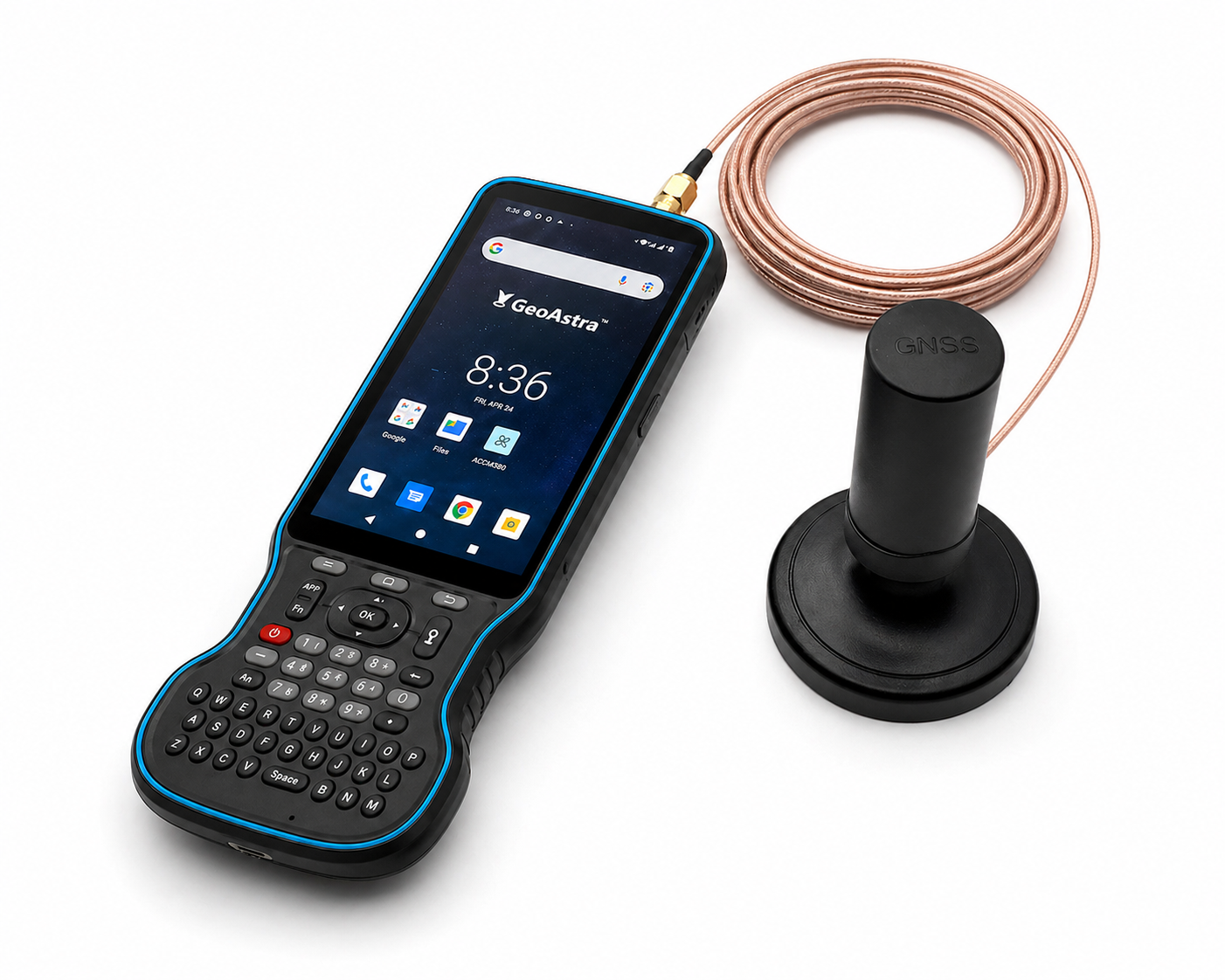
Columbus HAK-1 Tri-Band Helical Antenna Kit
The Y55G device antenna is replaceable and compatible with a male SMA connector.
For example, you can replace the original Y55G antenna with the Columbus HAK-1 Helical Antenna Kit. The HAK-1 magnetic base makes it more convenient to position the antenna exactly where you want to collect positioning data.

Product Resources
Official Documents:
Software Downloads:
How to Articles and Blogs:
Tech Support Topics and Forums: