Navisys GR-903 RTK GNSS Receiver ( RTK Base & Rover, L1/L2 Dual-Band, USB & Bluetooth Dual Interfaces, 1.4 cm accuracy, Android "SPPRTK" app with data logging and location sharing features)
Navisys GR-903 RTK GNSS Receiver ( RTK Base & Rover, L1/L2 Dual-Band, USB & Bluetooth Dual Interfaces, 1.4 cm accuracy, Android "SPPRTK" app with data logging and location sharing features)
Country of Origin: Taiwan
Couldn't load pickup availability
Navisys GR-903 is a RTK GNSS receiver offering centimeter-level positioning accuracy, ideal for autonomous driving, navigation, data logging, and other applications that require clear sky visibility. This receiver is user-friendly, with simple USB connectivity for computers and Bluetooth capability for seamless integration with GIS/GPS applications on Android devices.
Equipped with the advanced u-blox ZED-F9P engine and a high-end antenna, the GR-903 supports dual-band (L1/L2) frequencies and a wide range of satellite constellations (GPS, GLONASS, BEIDOU, GALILEO, QZSS, and SBAS). Its RTK technology leverages all visible satellites, ensuring precise navigation solutions when processed with correction data.
Flexibly designed to function as either a base or a rover, the GR-903 adapts to various operational needs. In its base mode, it generates continuous RTCM 3.3 correction data, while as a rover, it processes this data to provide real-time, centimeter-level positioning.
A distinctive feature of the GR-903 is its Moving Baseline (MB) capability, which allows both base and rover components to remain mobile while maintaining accurate positional calculations. This feature is particularly beneficial for dynamic applications such as UAV (Unmanned Aerial Vehicle) tracking and attitude sensing in moving vehicles or equipment, where precise relative positioning is crucial.
The GR-903 is fully configurable via Ublox U-center software and is compatible with multiple operating systems, including Android, Linux, and Windows. Its support for Windows location sensor is a standout feature, setting it apart from many other RTK GNSS receivers.
Features:
- Multi-band Support: L1/L2 bands.
-
GNSS/Multi-satellite Systems:
- Compatibility with GPS, GLONASS, BEIDOU, Galileo, QZSS, and SBAS.
- SBAS includes WAAS, EGNOS, MSAS, GAGAN.
-
Max RTK Update Rates:
- Up to 8Hz for full constellations.
- Up to 15Hz for moving baseline dual-satellite systems (e.g., GPS/GLONASS).
- Up to 20Hz for single-satellite systems (e.g., GPS only).
- DGNSS Support: RTCM 10403.3 version 3 for RTK fix.
-
High Sensitivity:
- Tracking sensitivity: -167 dBm.
- Acquisition sensitivity: -148 dBm.
- Built-in Antenna: L1/L2 patch antenna for supported satellite systems.
- Backup Battery: For faster position fixing.
- Interface Support: USB/UART TTL/RS232.
- Bluetooth: SPP support.
- Low Power Consumption: 118 mA for average tracking (USB, L1: 37, L2: 27 satellites).
- Windows Location Sensor Support.
- A-GNSS Services: OMA SUPL 1.0 compliant.
- Operating System Compatibility: Linux and Android.
- Waterproof Rating: IP67.
-
LED Indicators:
- Green LED for position fix.
- Orange LED for RTK fix.
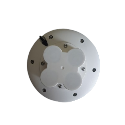
- Pole Mounting: Support via quad-M3x8 screw holes for RTK base.
-
Magnet Options:
- Disk only (without magnet).
- Disk + pedestal with magnet.
- EMI Shielded.
- Operating Temperature: -40°C to 85°C.
Technical Specs:
-
Supported Satellite Systems Frequencies (MHz) :
- GPS/SBAS/QZSS: L1C/A (1575.42 ), L2C (1227.60)
- GLONASS:
- L1OF (1602+k*0.5625, k= -7,…,5,6),
- L2OF (1246+k*0.4375, k= -7,…,5,6),
-
Galileo:
-
- E1-B/C (1575.42),
- E5b (1207.140).
-
BeiDou:
- B1I (1561.098),
- B2I (1207.140).
-
Position Accuracy (RTK baseline up to 20km; 24 hours static):
-
Horizontal:
- RTK: 1 cm + 1 ppm CEP,
- SBAS: 1 m CEP,
- PVT: 1.5 m CEP.
-
Vertical (result with 1km baseline):
- RTK: 1 cm + 1 ppm R50.
-
Horizontal:
-
Velocity Accuracy:
- Less than 0.05 m/s for speed,
- Less than 0.3° for heading (50% @ 30 m/s for dynamic operation).
-
Time Pulse Signal:
- Frequency range: 0.25 Hz to 10 MHz^3,
- RMS: 30 ns, 99%: 60 ns.
-
Time To First Fix (TTFF) (All at -130 dBm):
- Hot start: 2 sec (GPS+Glonass+Galileo+BeiDou),
- Aided start: 2 sec (GPS+Glonass+Galileo+BeiDou),
- Cold start: 25 sec (GPS+Glonass+Galileo+BeiDou).
-
Sensitivity (GPS+Glonass+Galileo+BeiDou):
- Acquisition: -148 dBm,
- Reacquisition: -160 dBm,
- Tracking & navigation: -167 dBm
-
Max. Update Rate:
- RTK:
- 8Hz for GPS+Glonass+Galileo+BeiDou,
- 15Hz for GPS+BeiDou,
- 20Hz for GPS.
- PVT:
- 10Hz for GPS+Glonass+Galileo+BeiDou,
- 25Hz for GPS+BeiDou and GPS.
- RAW:
- 20Hz for GPS+Glonass+Galileo+BeiDou,
- 25Hz for GPS+BeiDou and GPS.
- RTK:
-
RTK Convergence Time:
- Less than 10 seconds for GPS+Glonass+Galileo+BeiDou and GPS+BeiDou ,
- Less than 30 seconds for GPS.
- Note: Depends on atmospheric conditions, baseline length, multipath conditions, satellite visibility and geometry.
-
Moving Base RTK Performance:
- Max. update rate: 8Hz for GPS+Glonass+Galileo+BeiDou, 10Hz for GPS+BeiDou and GPS.
- Heading accuracy: 0.4° for all configurations.
-
Max. Altitude: 50,000 meters.
-
Max. Velocity: 500 meters/second.
-
Protocol Support (Default Settings):
- NMEA 0183 up to v 4.11, ASCII: GGA, GLL, GSA, GSV, RMC, VTG.
- UBX: u-blox proprietary, binary.
- RTCM 3.3: binary.
- UART1 & 2: 38400bps, N-8-1.
- UART1: NMEA, UBX, RTCM 3.3 enabled. Only NMEA output.
- UART2: RTCM 3.3 enabled, no output, NMEA disabled, UBX not supported.
-
Augmentation System Support:
- QZSS: Supports L1S SLAS. Correction data broadcasted on L1.
- SBAS: WAAS, EGNOS, MSAS, GAGAN.
- DGNSS: RTCM 10403.3.
- Rover mode messages (RTCM): 1001~1012, 1033, 1074, 1075, 1077, 1084, 1085, 1087, 1094, 1095, 1097, 1124, 1125, 1127, 1230, 4072.0.
- Base mode messages (RTCM): 1005, 1074, 1077, 1084, 1087, 1094, 1097, 1124, 1127, 1230, 4072.0, 4072.1.
-
Dynamics: Less than 4g.
- Environmental Data
- Operating temperature: -40 ~ 85℃
- Storage temperature: -40 ~ 85℃
- Waterproof level: IP67
- Dimensions:
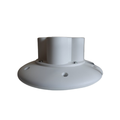
- Dish diameter: 116mm
- High: 24.6mm (without pedestal)
- High: 56.8mm (with pedestal)
- Mounting: Screw type: M3x8 mm
- Fixing screw holes (at the bottom of the disk, covered by pedestal):

- Pedestal magnet: Yes
Below screenshot shows the Deviation Map when a RTK GNSS Receiver got the "3D/DGNSS/FIXED" in U-Center Software.

The actual meaning of the Fix Modes status:
- “3D” fix mode: 3m CEP accuracy, no RTK
- “3D/GNSS” fix mode: 2.5m CEP accuracy, no RTK
- “3D/DGNSS/Float” fix mode: 20cm CEP, RTK position stabling
- “3D/DGNSS/FIXED” fix mode: 2cm CEP, RTK position stabled
The GR-903 comes with the SPPRTK Android app.
This app transforms the GR-903 into a versatile tool, serving as:
a. An RTK GNSS data logger,

b. A GNSS receiver with centimeter-level accuracy,

c. And a portable RTK Base Station.

What is main difference between a RTK GNSS receiver and a traditional GNSS receiver?
The main difference is RTK GNSS takes in the correction stream, but traditional GNSS doesn't.
RTK is short for real time kinematics. A RTK capable GNSS receiver takes in the normal signals from the Global Navigation Satellite Systems along with a correction stream to achieve 1cm positional accuracy. GNSS includes satellites from GPS (USA), GLONASS (Russia), Beidou (China), and Galileo (Europe). On top of these signals an RTK receiver takes in an RTCM correction stream and then calculates your location with 1cm accuracy in real time.
RTK is a technique used to improve the accuracy of a GNSS receiver. Traditional GNSS receivers, like the one in a smartphone, could only determine the position with 2-4 meters (7-13 feet) accuracy. RTK can give you centi-meter accuracy.
Why can RTK GNSS achieve so much better accuracy than standalone GNSS receivers?
GNSS receivers measure how long it takes for a signal to travel from a satellite to the receiver. Transmitted signals travel through the ionosphere and atmosphere and are slowed down and perturbed on the way. For example, travel time on a cloudy day and in clear sky conditions would be different. That is why it is difficult for a standalone receiver to precisely determine its position.
RTK(Real Time Kinematic) technology solves this issue by using correction services. In the RTK method, a user receiver gets correction data from a single base station or from a correction service from Internet. It then uses this data to eliminate most of the GNSS errors. RTK is based on the principle that the base station and the user receiver are located close together (maximum 40 km or 25 miles apart) and therefore “see” the same errors. For example, since the ionospheric delays are similar for both the user and the reference station, they can be cancelled out of the solution, allowing higher accuracy.
Which correction services do you recommend for GR-903?
We highly suggest the GR-9028 Portable RTK Base for your very own NTRIP correction service. It works perfectly with the GR-903 RTK Rover to give you a complete RTK solution. Set up quickly, flexible NTRIP caster mount point, and easily deploy it near your rovers for super accurate correction data. This will totally revolutionize your RTK needs. See it here and gain control of your RTK solution!
Other than GR-9028, there are many correction services publicly available. Free of charge or by a small fee. They share correction data over the Internet. This technology is called NTRIP. NTRIP is a good option for areas with 3G/4G LTE/5G network coverage and a vast network of NTRIP bases nearby.
Below are the NTRIP correction service sources for your reference:
Which NTRIP client do you recommend for GR-903?
We recommend Lefebure NTRIP Client.
Actually, most NTRIP clients in the market are capable. For example, the Ntrip client in ublox U-center.
Below is the screenshot of the Windows version of Lefebure NTRIP Client with "RTK FIXED".

Do you have a sample setup of U-Center NTRIP client?
Yes, please see the below screenshot.

Functioning as an RTK Base for Ardupilot’s Mission Planner
Along with all the advanced features mentioned above, the GR-903 is fully compatible with Ardupilot. It can be easily set up as an RTK base to inject RTK correction data into Ardupilot’s Mission Planner, which then transmits the data to an RTK rover connected to the flight control platform. The setup process is simple and straightforward—please refer to this document for guidance.
Product Resources
Official Documents:
User Guides:
YouTube Videos:
App Downloads:
(To download the "SPPRTK" app for Android devices, simply click the link below that corresponds to your device.)
Driver Downloads:
-
 Windows 10 / 11 driver installation guide
-
 GNSS Sensor Device driver for Windows 10 /11
-
 Linux driver installation guide
-
 Android connection instruction
Tool Downloads:
Factory Default Configure files Downloads:
How to Articles and Blogs:
RTK Rover:
-
 How to connect a GPS/GNSS Receiver to Google Earth on Windows?
-
 How to use a RTK GNSS Receiver for Android: A Step-by-Step Guide
-
 Utilizing a USB/Bluetooth RTK GNSS Receiver with a Windows 10/11 Laptop: A Step-by-Step Guide
-
 How to Connect a USB/Bluetooth RTK GNSS Receiver to Windows? (Accessing NTRIP Through an Android Phone’s Internet Connection)
-
 Utilizing a RTK GNSS Receiver for Linux: A Step-by-Step Guide
-
 Utilizing a USB/Bluetooth RTK GNSS Receiver for High Accuracy Data Logging: A Step-by-Step Guide
-
 Uninstall “Windows Location Sensor”: A Step-by-Step Guide
-
 How to connect a GNSS Receiver to Windows Maps (or Windows Location Service)??
-
 NTRIP RTK products buyers’ guide
RTK Base:
-
 Build your very own NTRIP RTK Base with just an RTK GNSS Receiver and 5 minutes
-
 How to setup an RTK Base station using a USB / Bluetooth RTK GNSS Receiver?
-
 How to obtain a highly accurate coordinate for your RTK base station?
-
 The Free NTRIP Caster from GPSWebShop
-
 NTRIP RTK products buyers’ guide
-
 NTRIP Casters in the Real World
-
 How accurate does your RTK base need to be?
